| |
 Weather Observations and Aerodrome Forecasts are called METARs (Aerodrome Weather Reports) and TAFs (Terminal or Aerodrome Forecasts). Weather Observations and Aerodrome Forecasts are called METARs (Aerodrome Weather Reports) and TAFs (Terminal or Aerodrome Forecasts).
Example of METAR
CYOW 211600Z 31010KT 15SM FEW100 FEW210 M16/M21 A3010 RMK AC1CI1 SLP202
Example of TAF
KORD 211556Z 2116/2218 07014G21KT 6SM -DZ BR OVC007 FM212300 07012G18KT 3SM -SN BR OVC006 TEMPO 2201/2203 1SM -SN BR OVC005 FM220300 07012KT 1 1/2SM -SN BR OVC006 FM220800 07011KT 3SM -SN BR OVC009 FM221300 07010KT 6SM -SN BR OVC010 FM221600 07008KT P6SM OVC012
METAR & TAF Decode table
US NWS TAF Decode
NAV CAnada Weather Guide
Winds and Temperatures are provided at points all over North America and over oceans by latitude and longtitude. A point forecast for a specific time and flight level will include the wind direction and speed in knots, followed by the forecast temperature. Where the wind is foreacst 100 knots or more, 50 is added to the direction, i.e. 791253 means the wind direction is from 290 degrees, the speed is 112 knots, and the temperature is minus 53 Deg. C.
Example of Wind Forecast (FD)
FD1US1
DATA BASED ON 211200Z
VALID 211800Z FOR USE 1400-2100Z. TEMPS NEG ABV 24000
FT...3000...6000...9000...12000....18000...24000...30000...34000...39000
BDL 3422 3029-12 2845-09 2858-11 7906-18 7810-30 781746 782555 791253
BGR 3219 3019-20 2927-24 2849-26 2881-26 7814-34 791345 298847 287048
CAR 3224 3512-19 0109-23 0407-30 9900-38 2830-40 295742 295343 294945
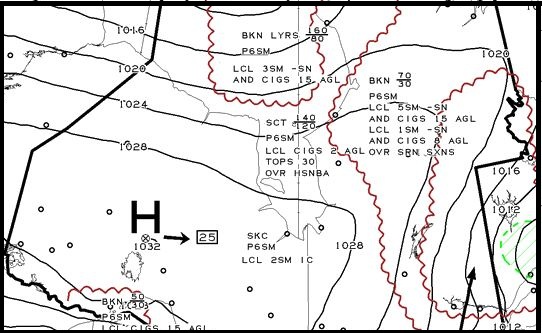
Area Forecasts include forecasts of significant weather over and area, including cloud layers, precipitation, lower visibilities, icing and turbulence, thunderstorms, isobars, etc. Area forecasts have evolved to be graphical in format, i.e. a picture of weather conditions over an area. The more traditional text products are usually also available. It is very important with area forecasts to take note of the valid time of the forecast, because the conditions only apply for the time specified.
Example of Graphical Area Forecast
| |

